
Ski Hire by Skiset
extra 5% off


Champoluc Weather (Next 3 days): The snow forecast for Champoluc is: Heavy rain (total 25.0mm), mainly falling Wed afternoon. Becoming colder with a light covering of snow, mostly falling on Wed afternoon. Freeze-thaw conditions (max 4°C on Mon afternoon, min -1°C on Sun night). Wind will be generally light.
Champoluc Weather (Days 4-6): A heavy fall of snow, heaviest during Thu afternoon. Freeze-thaw conditions (max 3°C on Sat afternoon, min -4°C on Thu night). Wind will be generally light.
| Resort | Snow Depth | Temp. (°C) | Wind (km/h) | Weather | ||
|---|---|---|---|---|---|---|
| Top Lift: | -3 | |||||
| Middle Lift: | 0 | |||||
| Bottom Lift: | 3 |
Latest snow reports near Champoluc:
Light rain reported from Aosta Airport at 546 metres elevation 5 kms NE of Pila but it is forecast cold enough for snow at the ski area from Pila
Light rain reported from Aosta Airport at 546 metres elevation 5 kms NE of Pila but it is forecast cold enough for snow at higher elevations in the ski area from Pila

Monday 29 | Tuesday 30 | Wednesday 1 | Thursday 2 | Friday 3 | Saturday 4 | ||||||||||||||
night | AM | PM | night | AM | PM | night | AM | PM | night | AM | PM | night | AM | PM | night | AM | PM | night | |
snow shwrs | some clouds | light rain | light snow | cloudy | light rain | mod. rain | mod. rain | light snow | heavy snow | mod. snow | heavy snow | light snow | cloudy | light snow | snow shwrs | some clouds | some clouds | rain shwrs | |
km/h | |||||||||||||||||||
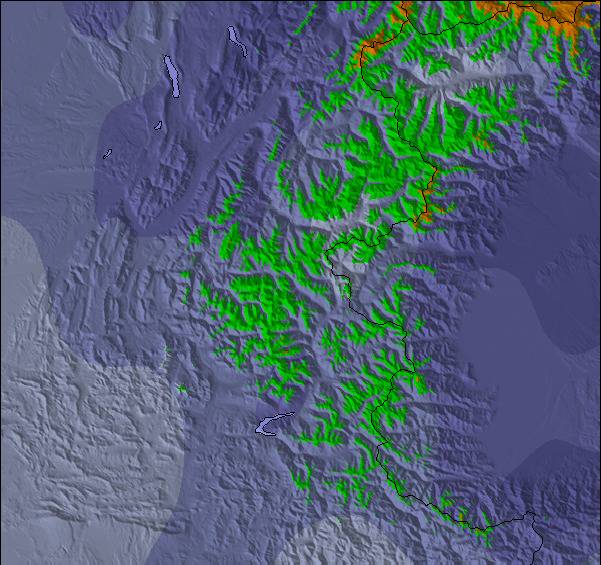
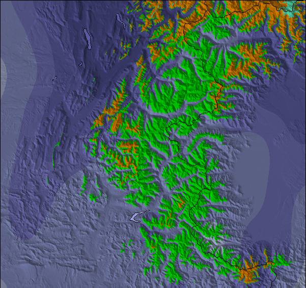
Snow map |  |  |  |  |  |  |  | ||||||||||||
2.0 | — | — | — | — | — | — | — | 4 | 11 | 9 | 10 | 4 | — | — | — | — | — | — | |
— | — | 1.0 | 1.0 | — | 2.0 | 6 | 6 | 9 | — | — | — | — | — | — | — | — | — | 1.0 | |
max°C | 0 | 3 | 4 | 3 | 3 | 4 | 3 | 3 | 2 | 2 | 1 | 1 | -1 | 0 | 1 | 0 | 2 | 3 | 3 |
min°C | -1 | 0 | 3 | 1 | 2 | 4 | 2 | 2 | 2 | 1 | 1 | 0 | -4 | -2 | 1 | -2 | 0 | 3 | 2 |
-4 | -2 | 1 | -1 | 0 | 2 | -1 | -1 | -2 | -2 | -2 | 0 | -8 | -6 | 0 | -2 | 0 | 3 | 1 | |
78 | 94 | 93 | 96 | 85 | 86 | 91 | 97 | 97 | 98 | 97 | 98 | 86 | 79 | 83 | 70 | 65 | 84 | 77 | |
1950 | 2550 | 2650 | 2400 | 2600 | 2650 | 2600 | 2600 | 2500 | 2450 | 2350 | 2100 | 1600 | 2100 | 2300 | 1600 | 2450 | 2650 | 2850 | |
— | 6:18 | — | — | 6:16 | — | — | 6:15 | — | — | 6:13 | — | — | 6:11 | — | — | 6:11 | — | — | |
— | — | — | 8:34 | — | — | 8:35 | — | — | 8:37 | — | — | 8:37 | — | — | 8:38 | — | — | 8:39 | |
Heavy rain (total 25.0mm), mainly falling Wed afternoon. Becoming colder with a light covering of snow, mostly falling on Wed afternoon. Freeze-thaw conditions (max 4°C on Mon afternoon, min -1°C on Sun night). Wind will be generally light.
A heavy fall of snow, heaviest during Thu afternoon. Freeze-thaw conditions (max 3°C on Sat afternoon, min -4°C on Thu night). Wind will be generally light.
Latest snow reports near Champoluc:
Light rain reported from Aosta Airport at 546 metres elevation 5 kms NE of Pila but it is forecast cold enough for snow at the ski area from Pila
Light rain reported from Aosta Airport at 546 metres elevation 5 kms NE of Pila but it is forecast cold enough for snow at higher elevations in the ski area from Pila
| Top snow depth: | — |
|---|---|
| Bottom snow depth: | — |
| Fresh snowfall depth: | 22 cm |
| Last snowfall: | 27 Apr 2024 |
| Snow Alerts | Create Alert |
0.1 | Bluebird Powder days Fresh snow, mostly sunny, light wind. |
|---|---|
0.6 | Powder days Fresh snow, limited sun, any wind. |
0.4 | Bluebird days Average snow, mostly sunny, light wind. |


The above table gives the weather forecast for Champoluc at the specific elevation of 2146 m. Our sophisticated weather models allow us to provide snow forecasts for the top, middle and bottom ski stations of Champoluc. To access the weather forecasts for the other elevations, use the tab navigation above the table. For a wider view of the weather, check out the Weather Map of Italy.
Click here to read further information on freezing levels and how we forecast our temperatures.
Overall 4.3 Based on 23 votes and 22 reviews
Did 3 years on trot to Champuloc, staying at Relais de Glaciers, lovely hotel, great spa, great food, wonderful staff. Went with Ski2 and can’t praise them enough. Great long cruising reds, nearly always deserted. Lovely off-piste opportunities right by the pistes. Having gone to different resorts year after year, fact that we did 3 years here in a row tells you everything. No nightlife, but that’s the price you pay for deserted pistes.
Bradley Mitchell from United Kingdom writes:
Did 3 years on trot to Champuloc, staying at Relais de Glaciers, lovely hotel, great spa, great food, wonderful staff. Went with Ski2 and can’t praise them enough. Great long cruising reds, nearly always deserted. Lovely off-piste opportunities right by the pistes. Having gone to different resorts year after year, fact that we did 3 years here in a row tells you everything. No nightlife, but that’s the price you pay for deserted pistes.
The Champoluc skiing weather widget is available to embed on external websites free of charge. It provides a daily summary of our Champoluc snow forecast and current weather conditions. Simply go to the feed configuration page and follow the 3 simple steps to grab the custom html code snippet and paste it into your own site. You can choose the snow forecast elevation (summit, mid-mountain or bottom lift) and metric/imperial units for the snow forecast feed to suit your own website…. Click here to get the code.
View detailed snow forecast for Champoluc at:
snow-forecast.com


 Nearest